Todd Smith is our 2026 Historical Hero
Written by Kayla White
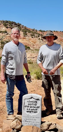
Todd Smith (left) with fellow investigator Mike Mitchell
Todd Smith (left) with fellow investigator Mike Mitchell
This year’s CCM Historical Hero is Todd Smith of Lubbock, Texas.
Todd’s experience comes from being the chief investigator at the Lubbock County District Attorney's office. Around 2012 Todd became interested in researching the Battle of Blanco Canyon as a hobby. Archaeologists placed the battle in Blanco Canyon, Floyd County, Texas, but there were inconsistencies. The age, placement, and amount of artifacts didn’t make sense.
About the battle:
In 1871 the U.S. sent Colonel Ranald Mackenzie after hostile Comanches. One night, the Comanches stampeded Mackenzie’s horses and took 70. The next day, Lieutenant Carter and his men chased them and lost Private Leander Gregg of the U.S. Cavalry. The Comanches then disappeared into a huge snowstorm. In a skirmish after the storm, Mackenzie was injured and two Comanches were killed.
Todd brought other investigators into the search and they pieced together what was missing from conventional archaeological research. They read every possible account of the battle they could find. Todd went to the Library of Congress and found a forgotten map that was crucial to the search. It turns out, the battle site wasn’t actually in Blanco Canyon. It was in southeastern Crosby County. They found artifact after artifact on the site, including shell casings, bullets, arrowheads, infantry buttons, and an 1854 Remington pistol.
They eventually found Gregg’s grave. Gregg was left on a weakened horse and was with Lieutenant Carter and 5 other men as Captain Heyl’s group retreated from the Comanches. Gregg’s carbine jammed and he couldn’t fire his revolver fast enough. The Comanche chief rode up to Gregg and shot him in the head, leaving his companions to quickly bury him.
Todd Smith will be at the Comanchero Rendezvous on June 6th at the museum to talk about these groundbreaking historical discoveries and how they were made.
New Museum Displays are only one Feature of Rendezvous 26'
Written by Marisue Potts - Photos by Richard Galle
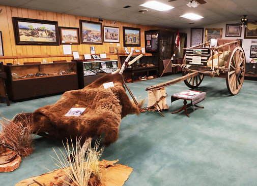
New Travois and Carreta
New Travois and Carreta
New Native American Display
On Saturday, June 6, the Comanchero Canyons Museum will feature new museum displays from 10:00-4:00, but that's just the beginning. Todd Smith will give his first hand account on documenting the first battle of the Red River War at 1:30. Readers of The Empire of the Summer Moon will find his account especially interesting. New displays link the Comanche and the Comanchero to the museum which covers five counties along the Caprock, Briscoe, Hall, Motley, and Floyd, as well as other locations and military campsites related to the Red River War of 1884.
New Native American Display
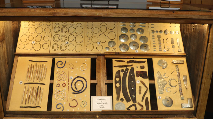
Memorial dedications will honor Choise Smith of Crosby County and Duane Johnson of Foard County for their work and contributions to the preservation of history. Experts will be on hand to identify artifacts from family or individual collections.
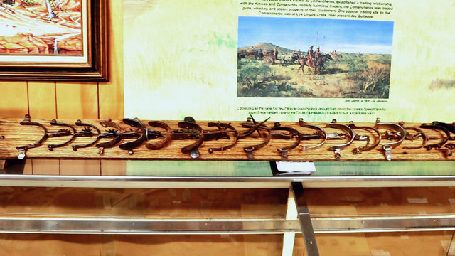
New Spurs Display
Outdoor activities will include the John Deere Ice Cream Machine, the village smithey pounding on an anvil, a bison specialist sharing information, reenactors with big guns, and a flint knapper creating tools at his colorful tipi.
New Spurs Display
Inside a delicious hamburger lunch will be served for $12 each from 11:30 to 1:00. Raffle tickets will be available for drawing throughout the day. The annual Rendezvous is an excellent time to honor the donors of the non-profit museum with their names incorporated into a documentary running continuously in the lobby. Join the fun and learn more about the history that took place in your backyard.
Comanchero Canyons Museum, 200 South 3rd, Quitaque, Texas